(This is going to be a very photo intensive post!)
Much of southern Oregon, especially the southeast, is a high desert in the rain shadow of the Cascades. Over the years we’ve done plenty of exploring in that area as a family, but my dad had a new area he wanted to explore along the Owyhee River. (According to the guidebook the Owyhee River was named for Hawaii because fur traders in the early 1800s imported natives from the Sandwich Islands, what is now Hawaii, to trap beaver in the area. The Hawaiins were promptly killed by the actual natives, and in their honor the English named it the Owyhee River, as Owyhee was apparently an early spelling of Hawaii. So, we actually did go to Hawaii…in Oregon.)
Our destination was the Chalk Basin, an area about 25 miles off of Highway 95, the main road in southeastern Oregon. While 25 miles doesn’t normally sound too daunting, the road is either dried (if you are lucky) mud or sharp lava rocks that eat sidewalls. Our trip in would end up taking 4 hours to cover the 25 miles.


On the way in you pass through one ranch, but then you are on BLM land the rest of the time.

The guidebook (by William Sullivan) says, in the event of rain “your car will sink to its hubs in mud and you will have to camp for a day or two until the ground hardens.” It was not raining as we drove in, but there had been some serious thunderstorms in the few days before we went, and although most of the road was passable, there were still some major mud holes. Well, that’s why my dad bought his Jeep. (Seriously, going to this particular place was a large part of the reason he bought the Jeep!)

The first few mud holes I just plowed right through. Fortunately, they were not anything significant. I got my first lesson as I charged into a relatively short mud hole, but I went a little right of the most recent tracks. I gunned it as it started to bog down, but it was too late and stupid traction control just slowed me down until I was stuck. There is no button to just turn off the traction control so it was time for 4wd low and “mud mode” on the Jeep, which does turn off traction control. I was able to slightly rock back and forth and I could feel a decent size rock ahead of the front tire. Fortunately, I was able to back up about 10 feet and then blast forward out of the hole. When we told one of Dad’s friends about this he said that if you don’t have to get out of the Jeep and use a jack/winch/tow you aren’t really stuck, so I guess we weren’t stuck, just delayed.


At this point I started to get more conservative as I hadn’t really thought we would get…delayed…in the earlier spot. Clearly this mud was a lot stickier and deeper than I thought. Then we came to a huge long mud hole. I had just started forward and had to back up as it was clear we weren’t coming close to driving through this one. A little ways back I saw a track going off the road around the area so we scoped it out to see if it was passable. Mud flat to muddy creek crossing to damp desert pasture – Dad was ready to turn around, but armed with his Jeep and my bravado we were going for it. We made it! No problem at all other than a bit of sliding around.
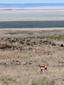
A bit down the road from all of this fun we saw an antelope standing on the side of the road. As we approached a coyote took off from somewhere near the antelope and I couldn’t figure out why it was standing there just looking at us.


As long as we are talking animals, we also saw a bunch of curlews. I had no idea curlews hung out in the desert.
As I was taking pictures of the antelope I noticed a vehicle stopped at the next big mud hole ahead of us. It figures – go all the way off the grid and there are still people out there. Of course, it ended up that they were very happy to no longer be alone because they were well and truly stuck. The guy was just driving along the edge of the hole and somehow his wheels slipped sideways and he drove into a very deep mud hole. We arrived at 5:00 p.m. and he had already been digging/jacking for four hours. He had raised his front wheel nearly a foot but he was still solidly stuck. Fortunately with his previous effort and the Jeep it was easy to pull him right out.

After this I was even more cautious. One time we again drove off into the grassland/pasture/lava fields well over 100 yards from the road to bypass a bunch of mud holes. As we finally made the end of the road overlooking the Chalk Basin, there was lighting and thunder all around. Amazingly we did not get rained on too hard, but there were major showers and lightning west, north and east.
You can’t have rainbows without rain!


And then the clouds lit up!


So all of this and I haven’t even started talking about the hiking yet!
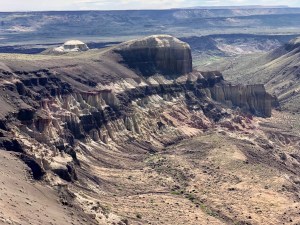
As described in the guidebook, at one time the Snake River used to flow across southern Oregon to the Pacific, but as mountains grew up the river was dammed, creating a massive lake in southern Idaho and southern Oregon between Boise and what is now the Steens Mountains in Oregon. It finally spilled out to the north, carving Hells Canyon on the Oregon/Idaho border. This massive lake led to all kinds of interesting deposits in eastern Oregon, including the silty layers that make up the Chalk Basin. Combined with the lava flows that followed the settling of the lake bed there are all kinds of great canyons and sculpted features to explore.


With the recent rain in the area the creek was surprisingly damp, with flowing water in places. Eventually we ran into a “dry” waterfall, which the guidebook says is where to turn back and climb up out of the canyon. Turn back? I don’t think so.


The guidebook should have said “if you don’t take my advice to turn back you are just going to come to an even larger waterfall that you cannot climb around,” but it didn’t.

So we had to climb out of the canyon anyway.


As we walked south along the bluff above the Owyhee River we started to see the amazing sculpted hoodoos and goblins that are the best part of the hike.

We hiked down to the river where we ran into the couple we pulled out of the mud hole the day before. They described their hike a little further south along the river so after a lunch we went for some more exploring.


The formations are each unique in appearance and structure.


This narrow cleft extends about 50 feet up the hill to a 40 foot high skylight.

We spent what was likely a couple hours just exploring this one little canyon in the formation. While I never like comparisons to Utah geology as I think Utah is so amazing, it was very cool to be able to wander directly into these formations and carefully climb around. Surprisingly, I was able to climb all the way out of this area up some tight slopes – something I never would have expected as most paths cliff out quickly.

After exploring we hiked back up to our camp along a different creek bed. We probably only hiked about 8 miles round trip, but we were still pretty beat.

The next morning we wanted to explore one more area the guidebook described as having a great overlook of more formations. This time our goal was to simply stay up high on the ridge and look down from the top. We drove just about a mile south and then hiked straight over to the river.


As you can imagine, I could post a ton of other pictures, but I’m sure you get the idea. The formations along this area are amazing and very easy to explore…as long as you can get there. Sullivan describes this area as “the national park that is not yet crowded with tourists — the wilderness that is not yet designated” and he is not exaggerating. Right now the only thing keeping the area from being overrun is its remoteness. Maybe it is a good thing not many people are reading this blog!


Fabulous! Thank you for sharing, Michal. So glad you were able to get your dad in and out for an adventure of a lifetime. I’ll be sure to tease him about the Jeep at the end of the rainbow
I enjoyed your write up! My wife and I have been exploring the Owyhees for only about 5 years or so and there is still so much too see. We live in south west Oregon so we only make one long trip per year out there. Only in the past two years have we begun to explore the chalk basin. Cheers!